Introduction
The words that follow provide a description of the challenge. It’s mainly a description of the route rather than lots of details of what you can see along the way. This will hopefully come when articles are written and posted on the web.
It has been broken up into stages and assumes you will be walking in a clockwise manner. To do the shorter routes, all you need to do is to decide which route you are going to do and read which stages relate to it from the table below the map. For each stage the distance, climb and estimated time is given along with the totals if you are doing the whole round. Don’t forget, if you go Anticlockwise the ascents become descents and you need to read right to left and bottom to top.
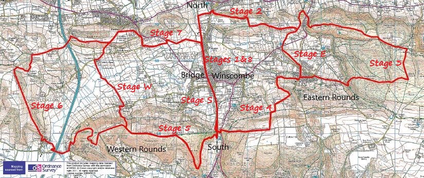

Click on the Short Cut to go to a stage description
To download the Route Description just click on the Download Button
The Full Winscombe Round – From Winscombe Railway Bridge
Stage 1
The Strawberry Line (1) (0.8km 1m climb 12mins)
Leaving the railway bridge behind you need to go north, walking toward Sandford through the Millennium Green and along the Strawberry Line. After 800m you will hopefully see the Cemetery on your left. Here you need to decide whether it’s a clockwise or anticlockwise round.
Stage 2
Sandford Hill (Stage: 4km, 125m, 72mins; Totals: 4.8Km, 126m, 1hrs 24mins)
For this route description we are going to go clockwise. In which case, you need to carry on along the Strawberry Line as it takes a drop into a cutting and under the Ilex Lane bridge. After another 700m of very enjoyable tree lined cycle path you come across two sets of steps: one to the left and one to the right, take the ones on the right. Follow the path from the top of the steps up to the Sandford Road, while looking at Thatchers Cider trees doing their thing making ‘apple juice’ (lovely in blossoms in Spring time) on the left hand side.
When you hit the road turn left, cross the road and in about 30m turn right up a small lane and right again up a small footpath. This should lead up between two gardens to a new kissing gate with the path leading off left up around the Sandford Quarry. If you have got yourself onto the right path it should head on up along a path through a wood, past some old Calcite mine workings for about 1km and then turn to the right to a stile after a further 200m.
After going over the stile if you turn left and through a gate, an open track should be before you which you can follow until just before it starts to head downhill after 400m. At this point there is a small bridleway on the right hand side; this is the track which you need to take. This initially heads downhill slightly, past a footpath on your right and left and then continues for nearly 1km where you get to a T junction. By going right at this point you start the ‘quarter round’ but if you are doing the full round, which this description is all about, you need to turn left.
Stage 3
Dolebury Warren & Black Down (Stage: 8.8Km, 298m, 161mins; total: 12.8Km, 424m, 3hrs 54mins)
This track continues for 700m until you see a footpath sign which is on your right, this takes you back on yourself slightly and heads downhill toward the A38. Don’t be tempted to take the first footpath after about 200m on your right; this path is steep on its way down to the road which can be slippery; it also brings you to the wrong crossing point on the A38.
Assuming you have got to the right A38 crossing point, you should see a lane directly in front of you, don’t take the lane which goes to the right but take the one that goes straight and up the hill. At the top of the hill, just before a pink house, there is a footpath on your left which you need to take up to a gate. Go through the gate and follow the path up to the Dolebury Warren (an iron age settlement). Here there are many different paths you can take through or around the settlement, over some fine Mendip limestone grassland and woods but all being well, you should end up at the other end of Dolebury Warren, in the south east corner, after 2km of taking in the views around you (navigational hint you can follow the Limestone Link path). From the top of the settlement if you stop and look around (assuming it’s not raining and the mist isn’t down) you should be able to make out the whole route, of which you have still got 28km to do.
Let’s assume that the newly acquired knowledge that you have only done 20% of the full round hasn’t made you just turn around and go home! Leave Dolebury Warren through the correct gate: you should have a track ahead of you, on which you turn right. In 30 metres you get to another track where you turn left. This next section can be quite sticky in the winter or after lots of rain at any time of the year but hang in there, it gets better as you are about to head up and over Black Down, which to make the obvious pun is UP a hill. Again, there are many paths which take you up Black Down, some drier than others, but the one I’m suggesting is about 900m after leaving Dolebury 200m after Rod’s Pot and provides a great view of Burrington Ham and Beacon Batch.
So head up the grassy track for about 1Km (plus 100m of climb) after which you should see a track (before the top) going off to your right heading towards Rowberrow Warren (but let’s call it a wood as it’s easier to identify), where a gate should greet you whilst you enter the wood. Take the Forest track straight ahead of you for about 800m, at which point there is a junction with the main path going off towards the right, however, you need to take the one going off to the left. As there are so many tracks in the wood, particularly since recent felling operations, this is where the navigation could go all wrong, so take care. However, if you have chosen the ‘right’ paths (sorry the left one) at this Y ish junction and keep following it downhill (and you find a four-leaf clover) you could and should get to a small steam. Cross this stream and take the path leading out of the wood going right up a hill, at the end of which you will be at the top of Lippiatt Lane.
There is now a nice downhill section to Shipham Village Centre, without mud, for just over 1Km but don’t forget to turn left onto ‘Barn Pool’ after about 800m otherwise you may miss the coffee shop and deli in Shipham. This is the point at which the ‘quarter’ round re-joins (if you had done this you would have reduced 8km to 1.7km but it would have been much less fun).
Stage 4
Winterhead Hill & Shute Shelve (Stage: 4.5Km 159m, 84mins; Totals: 17.3Km, 583m, 5hrs 17mins)
At the main road through Shipham, cross the road and walk in front of the Penscot Inn and take the small footpath which looks to go around the back of the Inn. After a stone stile head directly down across the field to the field bottom corner, where you are met with another stile. By taking the path behind it you end up in a small hamlet called Winterhead. When you get to the track which passes through the hamlet, turn left and follow this heading towards Winterhead Hill. After going over a stile the footpath heads off to the left up the hill, on what looks to be an old track way. After 400m you meet The Mendip Way where you turn right and follow this over another stone stile, across a field, over another stile close to a Farm where you turn left onto a track for 300m and then turn right at a T Junction with the Winscombe Drove. 150m after the T junction there is a path that takes you up the hill to the Callow Drove. Here you can also take the Mendip Way (to avoid the hill) by going straight on but this track is normally extremely muddy (even in the summer) and by going up hill you keep your boots clean (er) and you get good views of Wavering Down 2Km ahead of you and Winscombe Village 200m below you.
Assuming you have gone up to the Callow Drove, when you get to the top field head slightly right and go through the kissing gate and turn right onto the Drove. If you keep following this path/track in near enough a straight line through gates, over stiles and down a long hill you should end up by the A38 again at Shute Shelve. But don’t forget to take in the views as you come down the hill, which was the reason for going all the way up the hill in the first place.
So you have now nearly done the whole half the round and very shortly I will describe how to sneak back to Winscombe for that earlier than expected cup of tea at one of the Winscombe cafes but in the meantime we just need to get over the A38 safely. Go slightly left and take the first right up Winscombe Hill toward Kings Wood car park.
At the car park you could make your life very easy for yourselves and just take the path that leaves the car park, up through Kings Wood (or what is left of it after the devastation of Ash Die Back) and on to Wavering Down. However, that takes a lot of fun out of the walk and 2km away from the total length. So let’s not do that, instead take the bridleway which goes downhill on the opposite side of the road from the car park and right through a small gate into the Slader’s Leigh Nature Reserve with its 130 plant species, including Devil’s-Bit Scabious, Cowslips, Betony, Common Spotted Orchids and Tormentil and many types of butterfly – wonderful.
Stage 5
Wavering Down (Stage: 4.4Km 219m 88mins; total: 21.7Km, 802m, 6hrs 45mins)
At the bottom of the small reserve, go right and drop onto the Strawberry Line again. Assuming you aren’t planning an early bath (ie you are doing the Eastern Half or Quarter and need to head back to Winscombe) turn right, toward the tunnel. Plunge into the darkness of the tunnel containing bat & cave spiders and hopefully appear into the light 380m later. In a very short while find a narrow path signed Kingswood on your right. At the top of this path, go through the small gate and keeping the fence line on your left, head up through a further gate to take in some serious ancient forest bathing as you wander through the lower path in Kings Wood with (during Springtime) its renown display of bluebells and wild garlic…… but trust me it’s great anytime of the year.
After 1Km of bathing in garlic you need to look out for a path which heads up onto the open spaces of Cross Plain. Once you have successfully mounted Cross Plain you need to head up the broad spur to Hill Farm to re-join the Mendip Way leading left to the Trig point of Wavering Down.
Watch out, if you are going to do the shorter routes of The Western Quarter, Central Half or Eastern Three Quarters, as you come off Wavering Down, in the next paragraph you need to look out for a gate and kissing gate on your right which goes down to Barton. If you don’t and get carried away by the sheer enjoyment of it all, you are going to do some extra steps.
Stage 6
Crook Peak & Loxton Hill (Stage: 9.5Km 273m 170 mins; Totals: 31.2Km, 1075m, 9hrs 36mins)
Now route finding becomes a lot easier for a while, unless you are shrouded in Mendip Mist, as all you have to do is follow the ridge and the Mendip Way until you get to the base of Crook Peak by a dry-stone wall corner. Here, and just for fun and to take out a slog, turn left along the track which gently rises for about 300m before turning right, nearly back on yourself, to bag the most mountainous top in the Mendips.
Leaving Crook Peak you can go straight down back to the wall corner or you can find a quieter path by heading west a little, turning north at the end of the Stoney outcrop, looping around on a grassy path back and finding the Mendip Way which is heading down the side of an old quarry. Leaving Crook Peak it is very enticing to try a direct route through the gorse, down to the road or Webbington but it will most likely end in a lot of tears, scratches and finding evidence of others who may have tried similar short cuts before you.
After you have finished sliding down the steep path of the The Mendip Way from the wall corner you can turn left at a T junction and follow a permissive path in the woods to a kissing gate after 300m. This then takes you down a track and footpath to the road. At the road turn left and at the next road junction turn right; just after the motorway bridge you should come across the Mendip Way signs taking you right and then across a field toward Loxton Church.
With the church on your right, go up the road and when you get to the main road through Loxton, follow the Mendip Way signs to get yourselves onto the path which takes you up Loxton Hill. The path up Loxton Hill (and this is a warning) is a long one. It’s not steep, it’s not normally muddy but it’s just a steady uphill track of over 2Km. This is ok, normally, but you have already done 27Km so it is just not fair. It could be worse, you could be doing the whole Mendip Way and walked 70Km, so it’s all about perspectives and doing one small step at a time and not thinking about it too much.
Once you have made it to the top you will be pleased to know that ‘most’ of the hill climbing is now behind you and Winscombe is just ‘around the corner’. But now you have to decide which way to go around Christon Plantation. So when you get to a track after the ‘hill’ turn right and right again till you get to the Keepers Cottage. Turn left and following the track with the woods on your left, you get to T junction where you turn right and head down to the M5 again. Note, you can do all this with the wood on your right by going around the other way …..it’s just up to you.
So you are now heading down to the motorway trying to avoid the ‘swimming pool’ size puddles by walking on the side of the track. After crossing the M5, hopefully by the bridge, you head up hill on a small road (did I say the hills were all over?) and take the track on the right through the farmyard just as the road bends to the left. Follow the track, with excellent views of Cook Peak across the Lox Valley for 1.2Km until you go past a cottage.
Stage 7
Banwell Hill (Stage 3.1Km 36m, 50 mins; Totals: 34.3Km 1111m, 10hrs 25mins)
At this point the Western Quarter re-joins the party from a path from the right; at the same time there is a gate and path leading off to the left. Take this footpath which goes diagonally across a field, through a kissing gate before getting to another track.
At this track turn right and follow this down for 600m to a small road . After arriving at the said small road, turn left, then turn right down the side of Banwell Castle with its roaming peacocks. At the base of the Hill you are going to be diverted for an extra 5 minutes. Don’t turn left into Rhodyate Farm and look for the footpath which crosses the fields but turn right and take the path on the left after about 70m cross a field and then turn left and follow you nose until the A371 – This is all due to a footpath diversion. Cross this road carefully, as cars move along it quite quickly. Take the track heading north (the original road) to get to a kissing gate on your right which takes you into a field heading east. Following the footpath signs and keeping in an easterly direction for 1.5km, if you are lucky, you will see the Parish Cemetery there before you, and yes, this was the one you left behind all those Kilometres before.
Stage 8
The Strawberry Line (2) (Stage: 0.9m, 5m, 14mins; totals: 35.2 total 1116m, 10hrs 39mins)
So, unless you want to do a lap of honour, the best and most efficient way of finishing the round is to turn right, retracing your steps of the last 800m back to the Millennium Green and Winscombe Railway Bridge and a well-earned rest.
And that is it. I hope you enjoyed the challenge, its views, history, wildlife and general beauty – well done!
Stage Descriptions to Allow Variations
In the following section you will find descriptions of the ‘short cuts’ to allow you do different routes. These all assume you are walking in a clockwise direction.
Stage E
The Eastern Quarter (Stage: 1.9Km, 57m 34mins)
Leaving the T Junction after completing stage 2, where the full route goes left, you need to turn right down a stoney track going toward Star and the A38. At the A38 turn right and cross the A38 where you can see a small lane (after about 30 m) called Cheddarcombe Lane. Go up this lane for about 50m and go over the stile on your left. In the field take the path which goes off to the right and up hill over the broken ground with the trees to your right. After a stile you will see Shipham Village Hall ahead of you and going to the right of it you get to the main road. Turn right and walk along the road until you get to centre of the village where you re-join the route at stage 4.
Stage W
The Western Quarter (Stage: 3.0Km, 63m 51mins)
At the base of Wavering Down there is gate and kissing gate where the Barton to Compton Bishop track meets the newly repaired drystone wall (Carried out by NT volunteers). If you turn right here and head downhill you will get to a stile and the bottom of the field. Go over the stile and turn left and head down the track past Barton Camp to the road. At the road turn right and after 150m there is a track with a footpath sign on your left which takes you across the wide Lox River valley. This path goes through a number of gates and fields including a small metal bridge over the River Lox itself. Just after the bridge there is a quick right and left so watch out for that. Now you should be heading toward Yarberry Farm. Look out for the Yarberry Stone, a Neolithic standing stone in a field to your right (this is on private land so just view from a distance). Take the footpath on the left (across a wood bridge) rather than going through Yarberry Farm and through a kissing gate onto the road. At this point and by the bend in the road there is another footpath which take you around the rear of Yarberry Farm and then diagonally up across a field to another gate and another small road. Straight opposite there is another footpath which heads up hill, swinging to the right to meet the ‘Round’ again by a cottage.
Stage S
The Strawberry Line (3) (Stage: 1.2Km, 18m, 20mins)
Leave the Railway bridge and head south along the Strawberry Line. After 500m you will see Winscombe Recreation ground, keep going along the path and after a further 700m you will see a sign for Sladers Leigh Nature Reserve. Here you can join the Round to start Stage 5 and go through the Tunnel, which you should see ahead of you or take the path through the reserve up to Kingswood Car park. So much choice!
